
Gracias por apoyar a este sitio ❤️
Haz una donación
Haz una donación
Mapa topográfico Dwyer
Haga clic en el mapa para ver la altitud.
Gracias por apoyar a este sitio ❤️
Haz una donación
Haz una donación
Acerca de este mapa
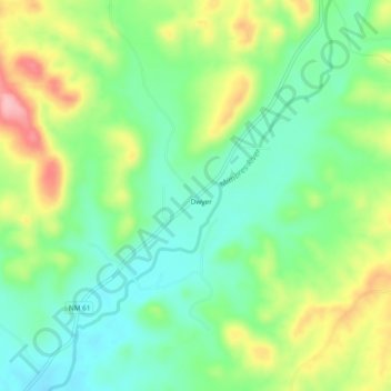
Nombre: Mapa topográfico Dwyer, altitud, relieve.
Lugar: Dwyer, Grant County, New Mexico, 88034, United States (32.60841 -107.88698 32.64841 -107.84698)
Altitud media: 1,616 m
Altitud mínima: 1,561 m
Altitud máxima: 1,713 m
Gracias por apoyar a este sitio ❤️
Haz una donación
Haz una donación
Otros mapas topográficos
Haga clic en un mapa para ver su topografía, su altitud y su relieve.
Bayard
United States > New Mexico > Grant County
Bayard is located in the southern foothills of the Pinos Altos Range and Mogollon Mountains in the southwestern portion of New Mexico and situated east of the Continental Divide at an elevation of approximately 5,800 feet (1,800 m). Gila National Forest lies north from here. A semi-arid desert of predominantly…
Altitud media: 1,816 m
Gracias por apoyar a este sitio ❤️
Haz una donación
Haz una donación