
Gracias por apoyar a este sitio ❤️
Haz una donación
Haz una donación
Mapa topográfico Killeen
Haga clic en el mapa para ver la altitud.
Gracias por apoyar a este sitio ❤️
Haz una donación
Haz una donación
Acerca de este mapa
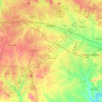
Nombre: Mapa topográfico Killeen, altitud, relieve.
Lugar: Killeen, Bell County, Texas, United States (31.02346 -97.82448 31.14103 -97.65132)
Altitud media: 266 m
Altitud mínima: 185 m
Altitud máxima: 340 m
Gracias por apoyar a este sitio ❤️
Haz una donación
Haz una donación
Otros mapas topográficos
Haga clic en un mapa para ver su topografía, su altitud y su relieve.
Belton
United States > Texas > Bell County
Belton is located 60 miles (97 km) north of Austin, 137 miles (220 km) south of Dallas, and 184 miles (296 km) west of Houston. It is near the center of Bell County at 31°3′32″N 97°27′48″W / 31.05889°N 97.46333°W / 31.05889; -97.46333 (31.058904, –97.463382). It is at the point where the…
Altitud media: 179 m