
Mapa topográfico Monarch Butterfly Biosphere Reserve
Mapa interactivo
Haga clic en el mapa para ver la altitud.
Acerca de este mapa
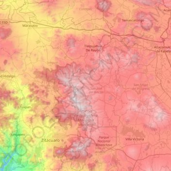
Nombre: Mapa topográfico Monarch Butterfly Biosphere Reserve, altitud, relieve.
Altitud media: 2,461 m
Altitud mínima: 904 m
Altitud máxima: 3,619 m
The reserve extends from the mountainous forests of eastern Michoacán to western Mexico State 100 km northwest of Mexico City. The reserve in Michoacán contains the highest elevations in the state, including peaks that reach 2,700 masl (metres above sea level). The climate is classified as being temperate and somewhat moist with a rainy season in the summer. The average maximum temperature is 22 °C (71 °F). Sub-climates exist in this area: cool and semi moist, semi cold and semi moist, and cold and semi moist.