
Mapa topográfico Manitou
Mapa interactivo
Haga clic en el mapa para ver la altitud.
Acerca de este mapa
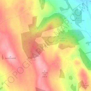
Nombre: Mapa topográfico Manitou, altitud, relieve.
Lugar: Manitou, Dumfries and Galloway, Scotland, United Kingdom (55.07817 -3.44932 55.07971 -3.44828)
Altitud media: 167 m
Altitud mínima: 45 m
Altitud máxima: 251 m
Otros mapas topográficos
Haga clic en un mapa para ver su topografía, su altitud y su relieve.
Langholm
United Kingdom > Scotland > Dumfries and Galloway
Langholm, Dumfries and Galloway, Scotland, DG13 0JQ, United Kingdom
Altitud media: 185 m
Annan
United Kingdom > Scotland > Dumfries and Galloway
Annan, Dumfries and Galloway, Scotland, DG12 5AW, United Kingdom
Altitud media: 26 m
Gatehouse of Fleet
United Kingdom > Scotland > Dumfries and Galloway
Gatehouse of Fleet, Dumfries and Galloway, Scotland, DG7 2HR, United Kingdom
Altitud media: 64 m