
Mapa topográfico Hemer
Mapa interactivo
Haga clic en el mapa para ver la altitud.
Acerca de este mapa
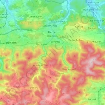
Nombre: Mapa topográfico Hemer, altitud, relieve.
Lugar: Hemer, Märkischer Kreis, North Rhine-Westphalia, 58675, Germany (51.31223 7.72022 51.41748 7.85342)
Altitud media: 326 m
Altitud mínima: 152 m
Altitud máxima: 547 m
Hemer is located at the north end of the Sauerland near the Ruhr river. The highest elevation, at 546 metres (1,791 ft), is in the Balver Wald in the south of the city. The lowest elevation, at 160 metres (525 ft), is at the Edelburg in the northeast.
Otros mapas topográficos
Haga clic en un mapa para ver su topografía, su altitud y su relieve.
Kierspe
Germany > North Rhine-Westphalia > Märkischer Kreis
Kierspe, Märkischer Kreis, North Rhine-Westphalia, 58566, Germany
Altitud media: 408 m
Dröschede
Germany > North Rhine-Westphalia > Märkischer Kreis > Iserlohn
Dröschede, Iserlohn, Märkischer Kreis, North Rhine-Westphalia, 58644, Germany
Altitud media: 235 m
Altena
Germany > North Rhine-Westphalia > Märkischer Kreis
Altena, Märkischer Kreis, North Rhine-Westphalia, 58762, Germany
Altitud media: 347 m
Lüdenscheid
Germany > North Rhine-Westphalia > Märkischer Kreis
Lüdenscheid, Märkischer Kreis, North Rhine-Westphalia, Germany
Altitud media: 384 m
Balve
Germany > North Rhine-Westphalia > Märkischer Kreis
Balve, Märkischer Kreis, North Rhine-Westphalia, 58802, Germany
Altitud media: 329 m
Hülseberg
Germany > North Rhine-Westphalia > Märkischer Kreis > Meinerzhagen
Hülseberg, Meinerzhagen, Märkischer Kreis, North Rhine-Westphalia, 58540, Germany
Altitud media: 494 m
Blechen
Germany > North Rhine-Westphalia > Märkischer Kreis > Kierspe > Blechen
Blechen, Kierspe, Märkischer Kreis, North Rhine-Westphalia, 58566, Germany
Altitud media: 376 m
Halver
Germany > North Rhine-Westphalia > Märkischer Kreis
Halver, Märkischer Kreis, North Rhine-Westphalia, 58553, Germany
Altitud media: 365 m