
Mapa topográfico Jasło
Mapa interactivo
Haga clic en el mapa para ver la altitud.
Acerca de este mapa
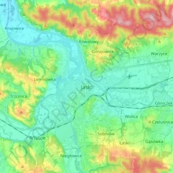
Nombre: Mapa topográfico Jasło, altitud, relieve.
Lugar: Jasło, Jasło County, Subcarpathian Voivodeship, Poland (49.71044 21.40176 49.78358 21.54169)
Altitud media: 265 m
Altitud mínima: 216 m
Altitud máxima: 378 m
Jasło [ˈjaswɔ] (listen) is a county town in south-eastern Poland with 36,641 inhabitants, as of 31 December 2012. It is situated in the Subcarpathian Voivodeship (since 1999), and it was previously part of Krosno Voivodeship (1975–1998). It is located in Lesser Poland, in the heartland of the Doły (Pits), and its average altitude is 320 metres above sea level, although there are some hills located within the confines of the city. The Patron Saint of the city is Saint Anthony of Padua.