
Mapa topográfico Wetlina
Mapa interactivo
Haga clic en el mapa para ver la altitud.
Acerca de este mapa
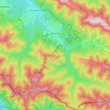
Nombre: Mapa topográfico Wetlina, altitud, relieve.
Altitud media: 857 m
Altitud mínima: 570 m
Altitud máxima: 1,235 m
The village is located near the source (springs) of the Weltinka river, a primary tributary of the Solinka river. South and west of the village are the Sękowa (1022 m) and Paprotna (1193 m) mountain peaks. East of the village are the range peaks of Połonina Wetlińska, with a maximum elevation of 1253 m.