
Mapa topográfico Nogent-le-Rotrou
Mapa interactivo
Haga clic en el mapa para ver la altitud.
Acerca de este mapa
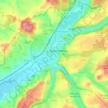
Nombre: Mapa topográfico Nogent-le-Rotrou, altitud, relieve.
Altitud media: 145 m
Altitud mínima: 98 m
Altitud máxima: 214 m
Nogent-le-Rotrou liegt am Fluss Huisne im Regionalen Naturpark Perche in einer Höhe von ca. 115 m. Nächstgrößere Städte sind Chartres (ca. 60 km nordöstlich), Le Mans (ca. 65 km südwestlich) und Alençon (ca. 65 km nordwestlich). Das Klima ist in hohem Maße vom Meer beeinflusst und deshalb nahezu frostfrei; Regen (ca. 655 mm/Jahr) fällt verteilt übers ganze Jahr.