
Haz una donación
Mapa topográfico Helmbach
Haga clic en el mapa para ver la altitud.
Haz una donación
Acerca de este mapa
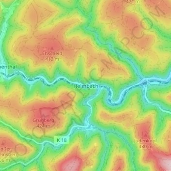
Nombre: Mapa topográfico Helmbach, altitud, relieve.
Altitud media: 323 m
Altitud mínima: 191 m
Altitud máxima: 480 m
Haz una donación
Otros mapas topográficos
Haga clic en un mapa para ver su topografía, su altitud y su relieve.
Carlsberg
Germany > Rhineland-Palatinate > Landkreis Bad Dürkheim
The municipality lies at the north edge of the Palatinate Forest between the Haardt range in the south and the Autobahn A 6 in the north in the Leiningerland at an elevation of 285 m above sea level. Carlsberg belongs to the Verbandsgemeinde of Leiningerland, whose seat is in Grünstadt.
Altitud media: 327 m
Haz una donación
Deidesheim
Germany > Rhineland-Palatinate > Landkreis Bad Dürkheim
From a local climatic point of view, Deidesheim is part of the climatically favoured foothill zone of the Weinstraße region. With a mean elevation of 235 m above sea level at the forest's edge, the lands of the Deidesheim area reach down to some 130 m above sea level at the lower mid-slope area in the…
Altitud media: 194 m
Haz una donación