
Gracias por apoyar a este sitio ❤️
Haz una donación
Haz una donación
Mapa topográfico Strathnairn
Haga clic en el mapa para ver la altitud.
Gracias por apoyar a este sitio ❤️
Haz una donación
Haz una donación
Acerca de este mapa
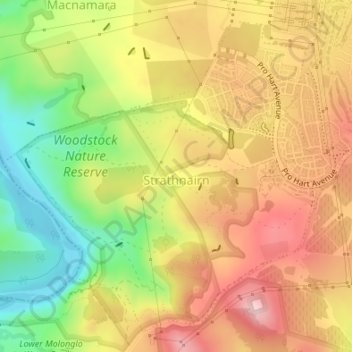
Nombre: Mapa topográfico Strathnairn, altitud, relieve.
Altitud media: 551 m
Altitud mínima: 430 m
Altitud máxima: 654 m
Gracias por apoyar a este sitio ❤️
Haz una donación
Haz una donación
Otros mapas topográficos
Haga clic en un mapa para ver su topografía, su altitud y su relieve.
Mount Rogers
Australia > District of Belconnen
Mount Rogers is a large hill, with an elevation of 704 metres (2,310 ft), located in the northern suburbs of Canberra, within the Australian Capital Territory, Australia. There is a park called the Mount Rogers Reserve at the crest of the hill, and a trig point at the summit.
Altitud media: 620 m
Gracias por apoyar a este sitio ❤️
Haz una donación
Haz una donación