
Mapa topográfico Avala
Mapa interactivo
Haga clic en el mapa para ver la altitud.
Acerca de este mapa
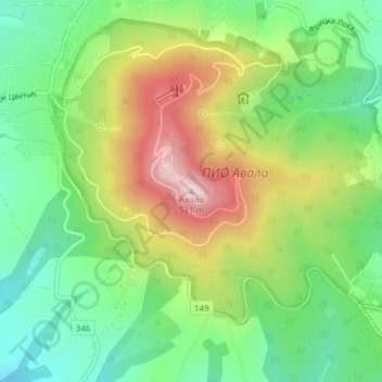
Nombre: Mapa topográfico Avala, altitud, relieve.
Altitud media: 297 m
Altitud mínima: 162 m
Altitud máxima: 500 m
It is still debated whether Šuplja Stena is a natural cave or was completely dug for the mining purposes. Remains of the Neanderthal culture were discovered in it. In his 1943 Prehistoric mine Šuplja Stena on Avala hill near Belgrade (Serbia), Vladimir Milojčić said that the "cave is old as Avala", formed by the volcanic activity and elevation of the terrain. The cave was first used by the wild animals and later by the prehistoric peoples, with animal and human remains, and prehistoric mining artefacts have been discovered. However, geographer Dragan Petrović in his work on the caves of Šumadija, lists caves on the present Belgrade's territory, but makes no mention of Šuplja Stena.