
Mapa topográfico East Staffordshire
Mapa interactivo
Haga clic en el mapa para ver la altitud.
Acerca de este mapa
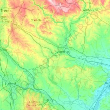
Nombre: Mapa topográfico East Staffordshire, altitud, relieve.
Altitud media: 132 m
Altitud mínima: 44 m
Altitud máxima: 380 m
Otros mapas topográficos
Haga clic en un mapa para ver su topografía, su altitud y su relieve.
Hanbury
United Kingdom > England > East Staffordshire > Hanbury
Hanbury, East Staffordshire, Staffordshire, West Midlands, England, DE13 8TP, United Kingdom
Altitud media: 104 m