
Mapa topográfico Keele
Mapa interactivo
Haga clic en el mapa para ver la altitud.
Acerca de este mapa
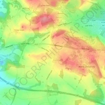
Nombre: Mapa topográfico Keele, altitud, relieve.
Altitud media: 166 m
Altitud mínima: 113 m
Altitud máxima: 217 m
Otros mapas topográficos
Haga clic en un mapa para ver su topografía, su altitud y su relieve.
Kidsgrove
United Kingdom > England > Staffordshire > Newcastle-under-Lyme
Kidsgrove, Newcastle-under-Lyme, Staffordshire, England, United Kingdom
Altitud media: 161 m
Swan Bank
United Kingdom > England > Staffordshire > Newcastle-under-Lyme > Madeley Heath
Swan Bank, Madeley, Madeley Heath, Newcastle-under-Lyme, Staffordshire, England, CW3 9JY, United Kingdom
Altitud media: 135 m
The Moss
United Kingdom > England > Staffordshire > Newcastle-under-Lyme > Madeley > The Moss
The Moss, Madeley, Newcastle-under-Lyme, Staffordshire, West Midlands, England, CW3 9NN, United Kingdom
Altitud media: 122 m