
Mapa topográfico Tazrouk
Mapa interactivo
Haga clic en el mapa para ver la altitud.
Acerca de este mapa
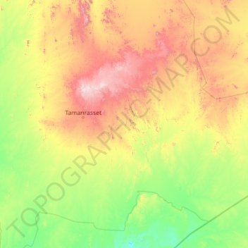
Nombre: Mapa topográfico Tazrouk, altitud, relieve.
Lugar: Tazrouk, Tazrouk District, Tamanrasset, Algeria (21.04675 5.81136 24.27594 10.27055)
Altitud media: 923 m
Altitud mínima: 474 m
Altitud máxima: 2,715 m
Tazrouk is located in the Hoggar mountains at an altitude of 1,827 metres (5,994 ft). Most of the town is located on the east bank of a wadi that runs past the town from the northwest to the southeast.
Otros mapas topográficos
Haga clic en un mapa para ver su topografía, su altitud y su relieve.
Sahara
Algeria > Tamanrasset > Tazrouk District > Tazrouk
Sahara, Tazrouk, Tazrouk District, Tamanrasset, Algeria
Altitud media: 650 m
Oued Tahaggart
Algeria > Tamanrasset > Tazrouk District
Oued Tahaggart, Tazrouk District, Tamanrasset, Algeria
Altitud media: 628 m