
Mapa topográfico Cameron Park
Mapa interactivo
Haga clic en el mapa para ver la altitud.
Acerca de este mapa
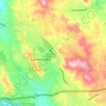
Nombre: Mapa topográfico Cameron Park, altitud, relieve.
Altitud media: 409 m
Altitud mínima: 307 m
Altitud máxima: 522 m
Cameron Park is situated in an interior chaparral zone or brush zone just east of the Central Valley. It is the closest population center to the Pine Hill Ecological Reserve. Native vegetation includes an abundance of redbud and manzanita bushes, and brush in general. Where treed the native trees are primarily gray pines, and oak trees with some small groves of ponderosa pines starting in the higher elevation zones. The elevation of Cameron Park varies between approximately 1,200 and 1,450 feet (370 and 440 m) above sea level, and is not considered in the snow zone of the Sierra Nevada mountains to the east, which are typically between 3,000 and 5,000 feet of elevation and above.
Otros mapas topográficos
Haga clic en un mapa para ver su topografía, su altitud y su relieve.
Cambridge Oaks
United States > California > El Dorado County > Cameron Park
Cambridge Oaks, Cameron Park, El Dorado County, California, 95672, United States
Altitud media: 376 m
Cameron Airpark Estates
United States > California > El Dorado County > Cameron Park
Cameron Airpark Estates, Cameron Park, El Dorado County, California, 95672, United States
Altitud media: 411 m
Bridlewood Canyon
United States > California > El Dorado County > Cameron Park
Bridlewood Canyon, Cameron Park, El Dorado County, California, 95672, United States
Altitud media: 376 m
Laurel Oaks Park
United States > California > El Dorado County > Cameron Park > Bar J Ranch
Laurel Oaks Park, Bar J Ranch, Cameron Park, El Dorado County, California, United States
Altitud media: 380 m