
Mapa topográfico Elbe
Mapa interactivo
Haga clic en el mapa para ver la altitud.
Acerca de este mapa
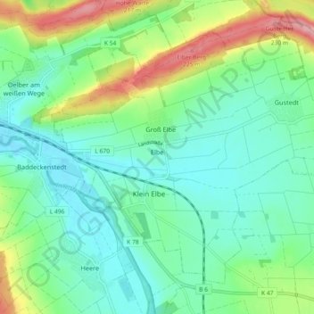
Nombre: Mapa topográfico Elbe, altitud, relieve.
Altitud media: 142 m
Altitud mínima: 105 m
Altitud máxima: 234 m
The Elbe rises at an elevation of about 1,400 metres (4,593 ft) in the Krkonoše (also known as Giant Mountains or in German as Riesengebirge) on the northwest borders of the Czech Republic near Labská bouda. Of the numerous small streams whose waters compose the infant river, the most important is the Bílé Labe, or White Elbe. After plunging down the 60 metres (197 ft) of the Labský vodopád, or Elbe Falls, the latter stream unites with the steeply torrential Malé Labe, and thereafter the united stream of the Elbe pursues a southerly course, emerging from the mountain glens at Jaroměř, where it receives Úpa and Metuje.