
Gracias por apoyar a este sitio ❤️
Haz una donación
Haz una donación
Mapa topográfico Besi Hill
Haga clic en el mapa para ver la altitud.
Gracias por apoyar a este sitio ❤️
Haz una donación
Haz una donación
Acerca de este mapa
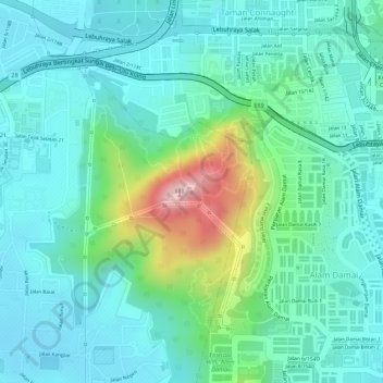
Nombre: Mapa topográfico Besi Hill, altitud, relieve.
Lugar: Besi Hill, Kuala Lumpur, 56000, Malaysia (3.07050 101.73064 3.07060 101.73074)
Altitud media: 103 m
Altitud mínima: 44 m
Altitud máxima: 287 m
Gracias por apoyar a este sitio ❤️
Haz una donación
Haz una donación
Otros mapas topográficos
Haga clic en un mapa para ver su topografía, su altitud y su relieve.
KLCC Park
Malaysia > Kuala Lumpur > Kuala Lumpur
The park was designed to showcase a heritage of tropical greenery by integrating man's creation with nature. The park itself contrasts as a calm environment in the midst of the hustle and bustle of the city. The park features many combinations of man-made design such as cements, water features and also natural…
Altitud media: 46 m
Gracias por apoyar a este sitio ❤️
Haz una donación
Haz una donación
Gracias por apoyar a este sitio ❤️
Haz una donación
Haz una donación
Kiara Hills Federal Park Family Recreation Zone
Malaysia > Kuala Lumpur > Kuala Lumpur
Altitud media: 81 m
Gracias por apoyar a este sitio ❤️
Haz una donación
Haz una donación
Gracias por apoyar a este sitio ❤️
Haz una donación
Haz una donación