
Mapa topográfico Hirta
Haga clic en el mapa para ver la altitud.
Acerca de este mapa
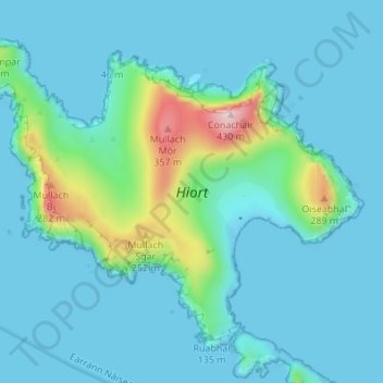
Nombre: Mapa topográfico Hirta, altitud, relieve.
Lugar: Hirta, Western Isles, Scotland, United Kingdom (57.79876 -8.61772 57.82838 -8.54960)
Altitud media: 58 m
Altitud mínima: -5 m
Altitud máxima: 425 m
Otros mapas topográficos
Haga clic en un mapa para ver su topografía, su altitud y su relieve.
North Rona
United Kingdom > Scotland > Western Isles
Rona (Scottish Gaelic: Rònaigh) is an uninhabited Scottish island in the North Atlantic. It is often referred to as North Rona to distinguish it from the island of South Rona in the Inner Hebrides. It has an area of 109 hectares (270 acres) and a maximum elevation of 108 metres (354 ft).
Altitud media: 4 m