
Gracias por apoyar a este sitio ❤️
Haz una donación
Haz una donación
Mapa topográfico Punilla
Haga clic en el mapa para ver la altitud.
Gracias por apoyar a este sitio ❤️
Haz una donación
Haz una donación
Acerca de este mapa
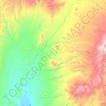
Nombre: Mapa topográfico Punilla, altitud, relieve.
Altitud media: 4,237 m
Altitud mínima: 3,319 m
Altitud máxima: 5,767 m
Gracias por apoyar a este sitio ❤️
Haz una donación
Haz una donación
Otros mapas topográficos
Haga clic en un mapa para ver su topografía, su altitud y su relieve.
Gracias por apoyar a este sitio ❤️
Haz una donación
Haz una donación
Cerro del Bolsón
While not of great height compared to the 6000 metre-plus peaks of the main chain of the Andes to the west, Bolsón is notable for its high topographic prominence (it ranks 69th in the world), resulting from its separation from the main chain by a relatively low saddle.
Altitud media: 5,057 m
Antofagasta de la Sierra
Antofagasta de la Sierra is a high altitude settlement, the majority of its inhabitants are descended from the Diaguitas and Atacameños.
Altitud media: 3,382 m
Gracias por apoyar a este sitio ❤️
Haz una donación
Haz una donación