
Mapa topográfico Flushing Meadows-Corona Park
Mapa interactivo
Haga clic en el mapa para ver la altitud.
Acerca de este mapa
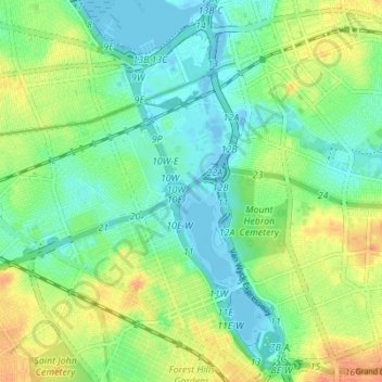
Nombre: Mapa topográfico Flushing Meadows-Corona Park, altitud, relieve.
Lugar: Flushing Meadows-Corona Park, New York, United States (40.71453 -73.86319 40.76675 -73.82557)
Altitud media: 15 m
Altitud mínima: -7 m
Altitud máxima: 40 m
Around 1907, contractor Michael Degnon, whose firm constructed the Williamsburg Bridge, the Cape Cod Canal, and the Steinway subway tunnel (used by today's 7 and <7> trains), purchased large tracts of marsh near Flushing Creek. At the time, the land was considered "all but worthless". Degnon envisioned using the site to create a large industrial port around Flushing Bay, similar to a terminal he developed in Long Island City. By 1911, Degnon had created a plan along with the United States Department of War and the Queens Topographical Bureau. The plan envisioned widening Flushing River and creating docks for ships, with numerous factories and freight facilities. Meanwhile, the residential areas of Corona were expected to become the primary residence for factory workers.
Otros mapas topográficos
Haga clic en un mapa para ver su topografía, su altitud y su relieve.
Brooklyn
United States > New York > New York
Brooklyn, Kings County, New York, United States
Altitud media: 9 m
Manhattan Island
United States > New York > New York
Manhattan Island, New York, United States
Altitud media: 17 m
Bush Terminal Park
United States > New York > New York
Bush Terminal Park, Brooklyn, Kings County, New York, United States
Altitud media: 8 m
Upper West Side
United States > New York > New York
Upper West Side, Manhattan Community Board 7, Manhattan, New York County, New York, United States
Altitud media: 23 m
Staten Island
United States > New York > New York
Staten Island, Richmond County, New York, United States
Altitud media: 9 m
Washington Heights
United States > New York > New York
Washington Heights, Manhattan Community Board 12, Manhattan, New York County, New York, United States
Altitud media: 25 m
Mill Pond Park
United States > New York > New York
Mill Pond Park, Bronx County, The Bronx, New York, United States
Altitud media: 18 m
Freshkills Park
United States > New York > New York
Freshkills Park, Veterans Road West, Rossville, Staten Island, Richmond County, New York, 10309, United States
Altitud media: 11 m
Starlight Park
United States > New York > New York
Starlight Park, Bronx County, The Bronx, New York, United States
Altitud media: 17 m
New York County
United States > New York > New York
New York County, New York, United States
Altitud media: 16 m
Fort Greene Park
United States > New York > New York
Fort Greene Park, Fort Greene, Kings County, New York, United States
Altitud media: 17 m
Gowanus Canal
United States > New York > New York
Gowanus Canal, Kings County, New York, United States
Altitud media: 11 m
Kings County
United States > New York > New York
Kings County, New York, United States, Marine Park
Altitud media: 4 m
Todt Hill
United States > New York > New York
Todt Hill, Richmond County, New York, 10304, United States
Altitud media: 50 m
Kissena Park
United States > New York > New York
Kissena Park, Queens County, New York, United States
Altitud media: 16 m
Queens County
United States > New York > New York
Queens County, New York, United States
Altitud media: 11 m
Hart Island
United States > New York > New York
Hart Island, New York, United States
Altitud media: 1 m
Coney Island Creek Park
United States > New York > New York
Coney Island Creek Park, Coney Island, Kings County, New York, United States
Altitud media: 2 m
Jerome Park Reservoir
United States > New York > New York
Jerome Park Reservoir, The Bronx, New York, United States
Altitud media: 35 m
Bronx County
United States > New York > New York
Bronx County, The Bronx, New York, United States
Altitud media: 21 m
Prospect Park
United States > New York > New York
Prospect Park, Kings County, New York, United States
Altitud media: 34 m
McCarren Park
United States > New York > New York
McCarren Park, Kings County, New York, United States
Altitud media: 7 m
Jamaica Bay
United States > New York > New York
Jamaica Bay, Queens, New York, 11693, United States
Altitud media: 0 m
Highland Park
United States > New York > New York
Highland Park, Queens County, New York, United States
Altitud media: 28 m
Todt Hill
United States > New York > New York
Todt Hill, New York, 10304, United States
Altitud media: 75 m
City Island
United States > New York > New York
City Island, The Bronx, New York, 10464, United States
Altitud media: 1 m
Jackie Robinson Park
United States > New York > New York
Jackie Robinson Park, Brooklyn, Kings County, New York, United States
Altitud media: 22 m
Forest Park
United States > New York > New York
Forest Park, New York, United States
Altitud media: 25 m
Shore Road Park
United States > New York > New York
Shore Road Park, Brooklyn, New York, United States
Altitud media: 9 m
Main Street Park
United States > New York > New York
Main Street Park, Brooklyn, Kings County, New York, United States
Altitud media: 11 m
Kings County
United States > New York > New York
Kings County, New York, United States
Altitud media: 9 m
Arbutus Lake
United States > New York > New York
Arbutus Lake, Staten Island, New York, United States
Altitud media: 9 m
Middleton Playground
United States > New York > New York
Middleton Playground, Brooklyn, Kings County, New York, United States
Altitud media: 13 m
Soundview Park
United States > New York > New York
Soundview Park, New York, United States
Altitud media: 6 m
Richmond County
United States > New York > New York
Richmond County, New York, United States
Altitud media: 9 m