
Haz una donación
Mapa topográfico Bundi
Haga clic en el mapa para ver la altitud.
Haz una donación
Bundi
The town of Bundi is situated 35 km from Kota and 210 km from Jaipur. It is located at 25°26′N 75°38′E / 25.44°N 75.64°E / 25.44; 75.64 and an average elevation of 268 metres (879 feet). The city lies near a narrow gorge, and is surrounded on three sides by hills of the Aravalli Range. A substantial wall with four gateways encircles the city. It is served by Bundi railway station on Kota-Chittorgarh rail line. Bundi is also known as "Choti Kashi" as there are many old temples in the city, which has been built by kings at their reign.
Haz una donación
Acerca de este mapa
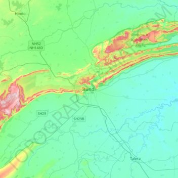
Nombre: Mapa topográfico Bundi, altitud, relieve.
Lugar: Bundi, Bundi Tehsil, Bundi District, Rajasthan, 323001, India (25.28161 75.47758 25.60161 75.79758)
Altitud media: 284 m
Altitud mínima: 224 m
Altitud máxima: 542 m
Haz una donación