
Haz una donación
Mapa topográfico Taunton
Haga clic en el mapa para ver la altitud.
Haz una donación
Acerca de este mapa
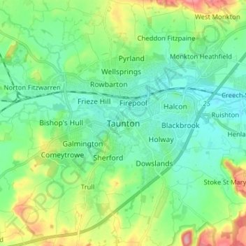
Nombre: Mapa topográfico Taunton, altitud, relieve.
Lugar: Taunton, Somerset, England, TA1 1JD, United Kingdom (50.97479 -3.14291 51.05479 -3.06291)
Altitud media: 39 m
Altitud mínima: 7 m
Altitud máxima: 122 m
Haz una donación
Otros mapas topográficos
Haga clic en un mapa para ver su topografía, su altitud y su relieve.
Haz una donación
Haz una donación
Haz una donación
Haz una donación
Haz una donación
Wiveliscombe
United Kingdom > England > Somerset
Wiveliscombe is a former borough, market and cloth making town, 5 miles (8 km) from the border between Devon and Somerset. It is situated at the foot of the Brendon Hills and acts as a gateway to Exmoor. At an altitude of 126 m (413 ft) Wiveliscombe is the highest town in Somerset after Dulverton.
Altitud media: 166 m
Haz una donación
Glastonbury Tor
United Kingdom > England > Somerset > Glastonbury
The Tor is in the middle of the Summerland Meadows, part of the Somerset Levels, rising to an elevation of 518 feet (158 m). The plain is reclaimed fen above which the Tor is clearly visible for miles around. It has been described as an island, but actually sits at the western end of a peninsula washed on…
Altitud media: 33 m
Haz una donación
Haz una donación
Haz una donación
Haz una donación
Haz una donación
Glastonbury Tor
United Kingdom > England > Somerset > Glastonbury
The Tor is almost surrounded by the low-lying Somerset Levels, rising to an elevation of 518 feet (158 m). The Levels are reclaimed fen above which the Tor is clearly visible for miles around. It has been described as an island, but actually sits at the western end of a peninsula washed on three sides by the…
Altitud media: 33 m
Wiveliscombe
United Kingdom > England > Somerset
Wiveliscombe is a former borough, market and cloth making town, 5 miles (8 km) from the border between Devon and Somerset. It is situated at the foot of the Brendon Hills and acts as a gateway to Exmoor. At an altitude of 126 m (413 ft) Wiveliscombe is the highest town in Somerset after Dulverton.
Altitud media: 166 m
Haz una donación
Mells Park
United Kingdom > England > Somerset > Vobster
The architect Edwin Lutyens had known the Horners, and Mells Park, since 1896. In 1918 he unsuccessfully tried to persuade the Horners to rebuild Park House. However, Reginald McKenna, the chairman of Midland Bank, and formerly Home Secretary and Chancellor of the Exchequer under Asquith, was married to Pamela…
Altitud media: 134 m
Haz una donación
Haz una donación
Haz una donación
Haz una donación
Haz una donación
Haz una donación
Haz una donación
Haz una donación
Haz una donación
Haz una donación
Haz una donación
Haz una donación
Haz una donación