
Mapa topográfico Elm Bank
Mapa interactivo
Haga clic en el mapa para ver la altitud.
Acerca de este mapa
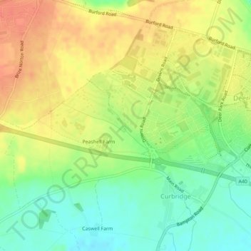
Nombre: Mapa topográfico Elm Bank, altitud, relieve.
Altitud media: 101 m
Altitud mínima: 77 m
Altitud máxima: 122 m
Otros mapas topográficos
Haga clic en un mapa para ver su topografía, su altitud y su relieve.
West Oxfordshire
United Kingdom > England > West Oxfordshire
West Oxfordshire, Oxfordshire, South East, England, United Kingdom
Altitud media: 119 m
Combe
United Kingdom > England > West Oxfordshire
Combe, West Oxfordshire, Oxfordshire, South East, England, United Kingdom
Altitud media: 106 m
Cornbury and Wychwood
United Kingdom > England > West Oxfordshire
Cornbury and Wychwood, West Oxfordshire, Oxfordshire, South East, England, United Kingdom
Altitud media: 146 m
Neat Enstone
United Kingdom > England > West Oxfordshire > Neat Enstone
Neat Enstone, West Oxfordshire, Oxfordshire, South East England, England, OX7 4NX, United Kingdom
Altitud media: 159 m