
Haz una donación
Mapa topográfico Kingsbury County
Haga clic en el mapa para ver la altitud.
Haz una donación
Acerca de este mapa
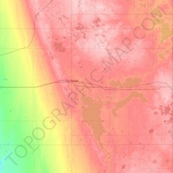
Nombre: Mapa topográfico Kingsbury County, altitud, relieve.
Lugar: Kingsbury County, South Dakota, United States (44.19473 -97.85368 44.54443 -97.12783)
Altitud media: 510 m
Altitud mínima: 403 m
Altitud máxima: 581 m
Haz una donación
Otros mapas topográficos
Haga clic en un mapa para ver su topografía, su altitud y su relieve.
Black Hills
United States > South Dakota > Pennington County
The Black Hills is an isolated mountain range rising from the Great Plains of North America in western South Dakota and extending into Wyoming, United States. Black Elk Peak, which rises to 7,242 feet (2,207 m), is the range's highest summit. The name of the range in Lakota is Pahá Sápa. It encompasses the…
Altitud media: 1,894 m
Mount Rushmore
United States > South Dakota > Pennington County
Mount Rushmore National Memorial is centered on a colossal sculpture carved into the granite face of Mount Rushmore (Lakota: Tȟuŋkášila Šákpe, or Six Grandfathers) in the Black Hills near Keystone, South Dakota. Sculptor Gutzon Borglum created the sculpture's design and oversaw the project's execution…
Altitud media: 1,562 m
Haz una donación
Black Hills
United States > South Dakota > Pennington County
The Black Hills is an isolated mountain range rising from the Great Plains of North America in western South Dakota and extending into Wyoming, United States. Black Elk Peak, which rises to 7,242 feet (2,207 m), is the range's highest summit. The name of the range in Lakota is Pahá Sápa. It encompasses the…
Altitud media: 1,894 m
Haz una donación
Black Elk Peak
United States > South Dakota > Pennington County
In September 2016, a team of professional surveyors obtained precise GNSS data over the course of two days and found the highest natural rock to be at 7,231.32 feet (2,204.11 m) NAVD88 and a nearby secondary peak located approximately 300 feet south of the lookout tower and unofficially named "McGillicuddy's…
Altitud media: 1,923 m
Haz una donación
Pactola Reservoir Recreation Area
United States > South Dakota > Pennington County
Altitud media: 1,491 m
Haz una donación
Haz una donación
Haz una donación
Haz una donación
Haz una donación
Haz una donación
Haz una donación
Haz una donación
Haz una donación
Watertown
United States > South Dakota > Codington County > Watertown
According to the United States Census Bureau, the city has a total area of 25.04 square miles (64.85 km2), of which 17.45 square miles (45.20 km2) is land and 7.59 square miles (19.66 km2) is water. Watertown sits on the Big Sioux River and two major lakes, Pelican Lake and Lake Kampeska. Most of Watertown…
Altitud media: 550 m
Haz una donación
Haz una donación