
Mapa topográfico Newbury
Mapa interactivo
Haga clic en el mapa para ver la altitud.
Acerca de este mapa
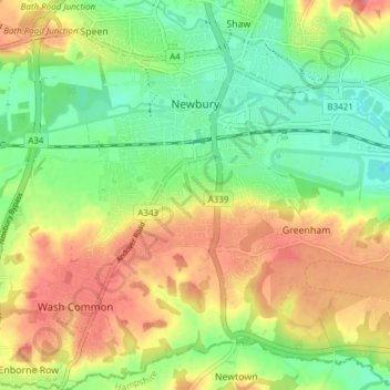
Nombre: Mapa topográfico Newbury, altitud, relieve.
Lugar: Newbury, West Berkshire, England, United Kingdom (51.36711 -1.35315 51.41456 -1.28819)
Altitud media: 97 m
Altitud mínima: 64 m
Altitud máxima: 135 m
Elevations vary from a minimum of 72 m above mean sea level to 122 m at Wash Common. Elevations reach 150–200 m in the directly adjoining hills. The River Kennet and the Kennet and Avon Canal flow east through the centre of the town to reach the Thames at Reading, while the River Lambourn (beside which is the country's largest horse-training paddocks in the Valley of the Lambourn Downs) partly forms its northern boundary, ending in the town. A tributary that is smaller still, the River Enborne, forms the southern boundary (and also the county boundary with Hampshire).
Otros mapas topográficos
Haga clic en un mapa para ver su topografía, su altitud y su relieve.
Welford
United Kingdom > England > West Berkshire
Welford, West Berkshire, England, United Kingdom
Altitud media: 124 m
Great Shefford
United Kingdom > England > West Berkshire
Great Shefford, West Berkshire, England, United Kingdom
Altitud media: 148 m
Bradfield
United Kingdom > England > West Berkshire
Bradfield, West Berkshire, England, United Kingdom
Altitud media: 77 m
Shaw
United Kingdom > England > West Berkshire
Shaw, West Berkshire, England, RG14 2DF, United Kingdom
Altitud media: 93 m
Hungerford
United Kingdom > England > West Berkshire
Hungerford, West Berkshire, England, United Kingdom
Altitud media: 131 m
Mortimer
United Kingdom > England > West Berkshire > Mortimer
Mortimer, West Berkshire, South East England, England, RG7 3RD, United Kingdom
Altitud media: 80 m
Reading
United Kingdom > England > West Berkshire > Reading
Reading, West Berkshire, South East England, England, RG1 1DA, United Kingdom
Altitud media: 56 m
Burghfield
United Kingdom > England > West Berkshire > Burghfield
Burghfield, West Berkshire, England, United Kingdom
Altitud media: 53 m
Brightwalton
United Kingdom > England > West Berkshire
Brightwalton, West Berkshire, England, United Kingdom
Altitud media: 178 m
Pangbourne
United Kingdom > England > West Berkshire > Pangbourne
Pangbourne, West Berkshire, South East England, England, United Kingdom
Altitud media: 64 m
Beenham
United Kingdom > England > West Berkshire > Beenham
Beenham, West Berkshire, South East England, England, United Kingdom
Altitud media: 77 m
Berkshire
United Kingdom > England > West Berkshire
Berkshire, West Berkshire, England, United Kingdom
Altitud media: 100 m