
Mapa topográfico Bâlea Lake
Mapa interactivo
Haga clic en el mapa para ver la altitud.
Acerca de este mapa
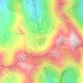
Nombre: Mapa topográfico Bâlea Lake, altitud, relieve.
Lugar: Bâlea Lake, Cârțișoara, Sibiu, Romania (45.60176 24.61549 45.60483 24.61897)
Altitud media: 2,080 m
Altitud mínima: 1,662 m
Altitud máxima: 2,457 m
Bâlea Lake (Romanian: Lacul Bâlea or Bâlea Lac, pronounced [ˈbɨle̯a]; Hungarian: Bilea-tó) is a glacier lake situated at 2,034 m of altitude in the Făgăraș Mountains, in central Romania, in Cârțișoara, Sibiu County. There are two chalets opened all the year round, a meteorological station and a mountain rescue (Salvamont) station. It is accessible by car on the Transfăgărășan road during the summer, and the rest of the year by a cable car from the "Bâlea Cascadă" chalet.
Otros mapas topográficos
Haga clic en un mapa para ver su topografía, su altitud y su relieve.