
Mapa topográfico Hartfield
Haga clic en el mapa para ver la altitud.
Acerca de este mapa
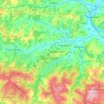
Nombre: Mapa topográfico Hartfield, altitud, relieve.
Lugar: Hartfield, Wealden, East Sussex, England, United Kingdom (51.04436 0.03185 51.14721 0.13203)
Altitud media: 108 m
Altitud mínima: 32 m
Altitud máxima: 244 m
Otros mapas topográficos
Haga clic en un mapa para ver su topografía, su altitud y su relieve.
Punnetts Town Recreation Ground
United Kingdom > England > East Sussex > Wealden > Punnett's Town > Chapel Cross
Altitud media: 125 m
Ashdown Forest
United Kingdom > England > East Sussex > Wealden
Ashdown Forest is an ancient area of open heathland occupying the highest sandy ridge-top of the High Weald Area of Outstanding Natural Beauty. It is situated 30 miles (48 km) south of London in the county East Sussex, England. Rising to an elevation of 732 feet (223 m) above sea level, its heights provide…
Altitud media: 117 m
Broadwater Warren Nature Reserve
United Kingdom > England > East Sussex > Wealden > Groombridge
Altitud media: 84 m
Best Beech Hill
United Kingdom > England > East Sussex > Wealden > Best Beech Hill
Altitud media: 120 m