
Gracias por apoyar a este sitio ❤️
Haz una donación
Haz una donación
Mapa topográfico Laupheim
Haga clic en el mapa para ver la altitud.
Gracias por apoyar a este sitio ❤️
Haz una donación
Haz una donación
Laupheim
The elevation within the city confines ranges from 509 m (1670 ft) above sea level at the bottom of the valley to 539 m (1768 ft) in the outlying suburban areas.
Gracias por apoyar a este sitio ❤️
Haz una donación
Haz una donación
Acerca de este mapa
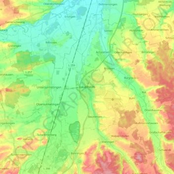
Nombre: Mapa topográfico Laupheim, altitud, relieve.
Altitud media: 523 m
Altitud mínima: 479 m
Altitud máxima: 592 m
Gracias por apoyar a este sitio ❤️
Haz una donación
Haz una donación
Otros mapas topográficos
Haga clic en un mapa para ver su topografía, su altitud y su relieve.
Kleinwinnaden
Germany > Baden-Württemberg > Landkreis Biberach > Bad Schussenried
Altitud media: 584 m
Burg
Germany > Baden-Württemberg > Landkreis Biberach > Bad Schussenried > Otterswang
Altitud media: 611 m
Bergerhausen
Germany > Baden-Württemberg > Landkreis Biberach > Biberach an der Riß
Altitud media: 579 m
Gracias por apoyar a este sitio ❤️
Haz una donación
Haz una donación