
Mapa topográfico Uxbridge
Haga clic en el mapa para ver la altitud.
Uxbridge
Uxbridge lies at a mean elevation of 130 feet (40 m) above mean sea level. Like much of the rest of the UK its climate is generally temperate, with few extremes of temperature or weather.
Acerca de este mapa
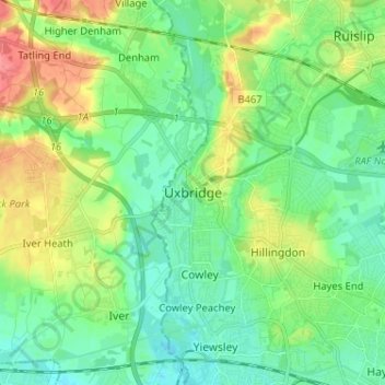
Nombre: Mapa topográfico Uxbridge, altitud, relieve.
Lugar: Uxbridge, Greater London, England, UB8 1SB, United Kingdom (51.50495 -0.52167 51.58495 -0.44167)
Altitud media: 44 m
Altitud mínima: 23 m
Altitud máxima: 89 m
Otros mapas topográficos
Haga clic en un mapa para ver su topografía, su altitud y su relieve.
Norwood Grove
United Kingdom > England > Greater London
After Anderson died, ownership passed to the Nettlefold family and subsequently to Frederick Nettlefold the brother of Joseph Nettlefold and a member of the family that founded the Nettlefolds Ltd. engineering firm which later became GKN. Nettlefold is commemorated, as a result of his charitable works, by a…
Altitud media: 58 m
Pymmes Brook
United Kingdom > England > Greater London
Prior to the Anglian glaciation, a "proto-Mole-Wey" river was flowing northwards from the Weald and North Downs, through the "Finchley depression" and Palmers Green, to join the proto-Thames somewhere around Hoddesdon, at what is today an altitude of around 60 metres. It was this river which, during the course…
Altitud media: 41 m