
Mapa topográfico Clarence
Mapa interactivo
Haga clic en el mapa para ver la altitud.
Acerca de este mapa
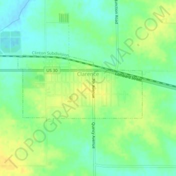
Nombre: Mapa topográfico Clarence, altitud, relieve.
Lugar: Clarence, Cedar County, Iowa, United States (41.88092 -91.07031 41.89108 -91.04465)
Altitud media: 253 m
Altitud mínima: 241 m
Altitud máxima: 267 m
Otros mapas topográficos
Haga clic en un mapa para ver su topografía, su altitud y su relieve.
Lowden
United States > Iowa > Cedar County
Lowden, Cedar County, Iowa, United States
Altitud media: 227 m
Cedar Valley
United States > Iowa > Cedar County
Cedar Valley, Cedar County, Iowa, United States
Altitud media: 229 m
Rock Creek
United States > Iowa > Cedar County
Rock Creek, Cedar County, Iowa, 52772, United States
Altitud media: 235 m
Clarence
United States > Iowa > Cedar County > Clarence
Clarence, Cedar County, Iowa, 52216, United States
Altitud media: 252 m
West Branch
United States > Iowa > Cedar County
West Branch, Cedar County, Iowa, 52538, United States
Altitud media: 228 m
Stanwood
United States > Iowa > Cedar County
Stanwood, Cedar County, Iowa, United States
Altitud media: 255 m