
Mapa topográfico Lake Charles
Mapa interactivo
Haga clic en el mapa para ver la altitud.
Acerca de este mapa
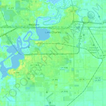
Nombre: Mapa topográfico Lake Charles, altitud, relieve.
Lugar: Lake Charles, Calcasieu Parish, Louisiana, United States (30.12450 -93.31686 30.27220 -93.12884)
Altitud media: 5 m
Altitud mínima: -5 m
Altitud máxima: 17 m
Lake Charles, located on a level plain about 30 miles (48 km) from the Gulf of Mexico, has an elevation of approximately 13 feet (4.0 m) above sea level, and is located on the banks of the Calcasieu River in southwestern Louisiana. It borders both Lake Charles and Prien Lake. Contraband Bayou, Henderson Bayou, and English Bayou flow through the city. Oak trees and pine trees dot the landscape; the lumber industry was once the main economic engine of the area. The Calcasieu Ship Channel, which allows large ocean-going vessels to sail up from the Gulf, also borders the city.
Otros mapas topográficos
Haga clic en un mapa para ver su topografía, su altitud y su relieve.
Sulphur
United States > Louisiana > Calcasieu Parish
Sulphur, Calcasieu Parish, Louisiana, 70663, United States
Altitud media: 6 m
University Place
United States > Louisiana > Calcasieu Parish > Lake Charles
University Place, Lake Charles, Calcasieu Parish, Louisiana, 70609, United States
Altitud media: 7 m
Moss Bluff
United States > Louisiana > Calcasieu Parish
Moss Bluff, Calcasieu Parish, Louisiana, United States
Altitud media: 6 m