
Mapa topográfico Mitchell
Mapa interactivo
Haga clic en el mapa para ver la altitud.
Acerca de este mapa
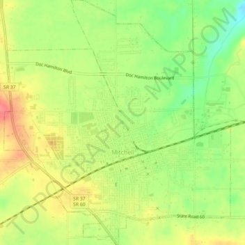
Nombre: Mapa topográfico Mitchell, altitud, relieve.
Lugar: Mitchell, Lawrence County, Indiana, 47446, United States (38.71975 -86.49511 38.75428 -86.45410)
Altitud media: 209 m
Altitud mínima: 174 m
Altitud máxima: 242 m
Otros mapas topográficos
Haga clic en un mapa para ver su topografía, su altitud y su relieve.
Otis Park
United States > Indiana > Lawrence County > Bedford
Otis Park, Bedford, Lawrence County, Indiana, United States
Altitud media: 186 m
Bedford
United States > Indiana > Lawrence County
Bedford, Lawrence County, Indiana, 47421, United States
Altitud media: 191 m
Rabbitville
United States > Indiana > Lawrence County
Rabbitville, Lawrence County, Indiana, 47446, United States
Altitud media: 196 m
Crawford
United States > Indiana > Lawrence County > Crawford
Crawford, Lawrence County, Indiana, United States
Altitud media: 198 m
Springville
United States > Indiana > Lawrence County > Springville
Springville, Lawrence County, Indiana, United States
Altitud media: 219 m