
Mapa topográfico Big Bear Lake
Mapa interactivo
Haga clic en el mapa para ver la altitud.
Acerca de este mapa
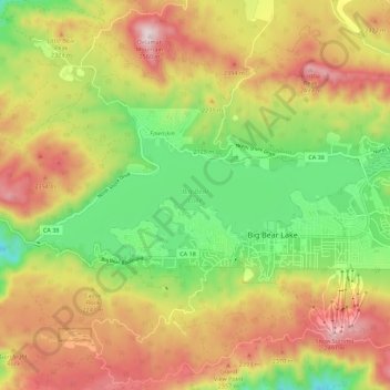
Nombre: Mapa topográfico Big Bear Lake, altitud, relieve.
Altitud media: 2,209 m
Altitud mínima: 1,905 m
Altitud máxima: 2,544 m
At a surface elevation of 6,743 ft (2,055 m) above sea level, it has an east-west length of approximately seven miles (11 km) and is approximately 2.5 miles (4.0 km) at its widest measurement, though the lake's width mostly averages a little more than 1⁄2 mi (0.8 km). These approximations are based on the lake having an optimum retainable water level. At dam's end, Big Bear measures its deepest water at 72 feet (22 m).
Otros mapas topográficos
Haga clic en un mapa para ver su topografía, su altitud y su relieve.
Moonridge
United States > California > San Bernardino County > Big Bear Lake
Moonridge, Big Bear Lake, San Bernardino County, CAL Fire Southern Region, California, 92314, United States
Altitud media: 2,211 m