
Haz una donación
Mapa topográfico Schliersee
Haga clic en el mapa para ver la altitud.
Haz una donación
Schliersee
Schliersee is located on the northeastern shore of the lake of the same name and is a well known resort in the Bavarian Alps. Schliersee provides scenic views of the surrounding mountains, in particular Aiplspitz, Jägerkamp (German), Brecherspitz and Bodenschneid, all belonging to the Mangfallgebirge range. The Spitzingsee area is at an elevation of 1,090 meters high and is a well known winter sports and mountain hiking centre.
Haz una donación
Acerca de este mapa
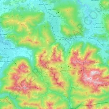
Nombre: Mapa topográfico Schliersee, altitud, relieve.
Lugar: Schliersee, Landkreis Miesbach, Bavaria, 83727, Germany (47.60823 11.79350 47.75662 11.94251)
Altitud media: 1,079 m
Altitud mínima: 712 m
Altitud máxima: 1,866 m
Haz una donación
Otros mapas topográficos
Haga clic en un mapa para ver su topografía, su altitud y su relieve.