
Mapa topográfico Rapid City
Mapa interactivo
Haga clic en el mapa para ver la altitud.
Acerca de este mapa
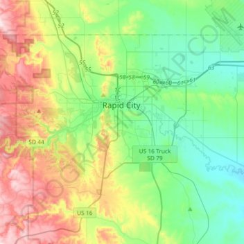
Nombre: Mapa topográfico Rapid City, altitud, relieve.
Lugar: Rapid City, Pennington County, South Dakota, United States (43.99492 -103.32635 44.13679 -103.03791)
Altitud media: 1,067 m
Altitud mínima: 914 m
Altitud máxima: 1,389 m
Rapid City is located at 44°04′34″N 103°13′42″W / 44.076188°N 103.228299°W / 44.076188; -103.228299. The downtown elevation of Rapid City is 3,202 feet (976 m). Rapid City is located in the shadow of Black Elk Peak, which at 7,242 feet (2,207 m), is the highest point east of the Rocky Mountains.
Otros mapas topográficos
Haga clic en un mapa para ver su topografía, su altitud y su relieve.
Black Hills
United States > South Dakota > Pennington County
Black Hills, Pennington County, South Dakota, United States
Altitud media: 1,894 m