
Mapa topográfico Waddington
Mapa interactivo
Haga clic en el mapa para ver la altitud.
Acerca de este mapa
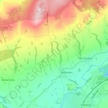
Nombre: Mapa topográfico Waddington, altitud, relieve.
Lugar: Waddington, Ribble Valley, Lancashire, England, United Kingdom (53.86998 -2.43837 53.92913 -2.39235)
Altitud media: 164 m
Altitud mínima: 18 m
Altitud máxima: 392 m
Otros mapas topográficos
Haga clic en un mapa para ver su topografía, su altitud y su relieve.
Read
United Kingdom > England > Lancashire > Ribble Valley
Read, Ribble Valley, Lancashire, England, United Kingdom
Altitud media: 114 m
Jamacia Wood
United Kingdom > England > Lancashire > Ribble Valley > Langho
Jamacia Wood, Billington and Langho, Langho, Ribble Valley, Lancashire, England, United Kingdom
Altitud media: 100 m