
Gracias por apoyar a este sitio ❤️
Haz una donación
Haz una donación
Mapa topográfico Tutzing
Haga clic en el mapa para ver la altitud.
Gracias por apoyar a este sitio ❤️
Haz una donación
Haz una donación
Acerca de este mapa
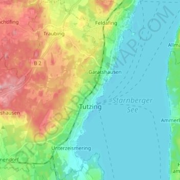
Nombre: Mapa topográfico Tutzing, altitud, relieve.
Lugar: Tutzing, Landkreis Starnberg, Bavaria, 82327, Germany (47.87502 11.18409 47.95693 11.29125)
Altitud media: 632 m
Altitud mínima: 581 m
Altitud máxima: 754 m
Gracias por apoyar a este sitio ❤️
Haz una donación
Haz una donación
Otros mapas topográficos
Haga clic en un mapa para ver su topografía, su altitud y su relieve.
5er-Grube
Germany > Bavaria > Landkreis Starnberg > Krailling > Kraillinger Innovations Meile KIM
Altitud media: 562 m
Gracias por apoyar a este sitio ❤️
Haz una donación
Haz una donación