
Mapa topográfico Baltimore
Mapa interactivo
Haga clic en el mapa para ver la altitud.
Acerca de este mapa
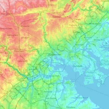
Nombre: Mapa topográfico Baltimore, altitud, relieve.
Lugar: Baltimore, Maryland, 21203, United States (39.13088 -76.77076 39.45088 -76.45076)
Altitud media: 65 m
Altitud mínima: -5 m
Altitud máxima: 219 m
Baltimore is in north-central Maryland on the Patapsco River close to where it empties into the Chesapeake Bay. The city is also located on the fall line between the Piedmont Plateau and the Atlantic coastal plain, which divides Baltimore into "lower city" and "upper city". The city's elevation ranges from sea level at the harbor to 480 feet (150 m) in the northwest corner near Pimlico.
Otros mapas topográficos
Haga clic en un mapa para ver su topografía, su altitud y su relieve.
Druid Hill Park
United States > Maryland > Baltimore
Druid Hill Park, Park Heights, Baltimore, Maryland, United States
Altitud media: 78 m
Middle East
United States > Maryland > Baltimore
Middle East, Baltimore, Maryland, United States
Altitud media: 29 m
Inner Harbor
United States > Maryland > Baltimore
Inner Harbor, Baltimore, Maryland, United States
Altitud media: 11 m
Broadway East
United States > Maryland > Baltimore
Broadway East, Baltimore, Maryland, United States
Altitud media: 36 m