
Mapa topográfico Largo
Mapa interactivo
Haga clic en el mapa para ver la altitud.
Acerca de este mapa
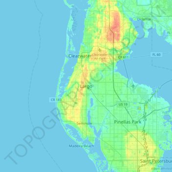
Nombre: Mapa topográfico Largo, altitud, relieve.
Lugar: Largo, Pinellas County, Florida, 33770-1815, United States (27.74947 -82.94732 28.06947 -82.62732)
Altitud media: 5 m
Altitud mínima: -2 m
Altitud máxima: 35 m
In 2010, Largo's total area was 18.6 square miles (48.1 km2), of which 17.6 square miles (45.6 km2) was land and 0.97 square miles (2.5 km2), or 5.22%, was water. As of 2004, there were 651 acres (2.6 km2) of park lands. The city's lowest elevation is sea level. At its highest, the city's elevation is about 69 feet (21 m). Largo is dotted with a number of lakes, the largest of which is Taylor Lake at 53 acres (210,000 m2). Allen's Creek drains northeast Largo, flowing into Tampa Bay. McKay Creek flows through southwest Largo into the Intracoastal Waterway. The McKay Creek basin is prone to flooding.
Otros mapas topográficos
Haga clic en un mapa para ver su topografía, su altitud y su relieve.
Ridgecrest
United States > Florida > Pinellas County > Largo > Baskin
Ridgecrest, Baskin, Largo, Pinellas County, Florida, United States
Altitud media: 18 m
Taylor Park
United States > Florida > Pinellas County > Largo > Ridgecrest
Taylor Park, Ridgecrest, Largo, Pinellas County, Florida, 33770, United States
Altitud media: 18 m
Anona
United States > Florida > Pinellas County > Largo > Anona
Anona, Largo, Pinellas County, Florida, 33774, United States
Altitud media: 9 m
Baskin
United States > Florida > Pinellas County > Largo > Baskin
Baskin, Largo, Pinellas County, Florida, 33778, United States
Altitud media: 14 m