
Mapa topográfico Mount Angel
Mapa interactivo
Haga clic en el mapa para ver la altitud.
Acerca de este mapa
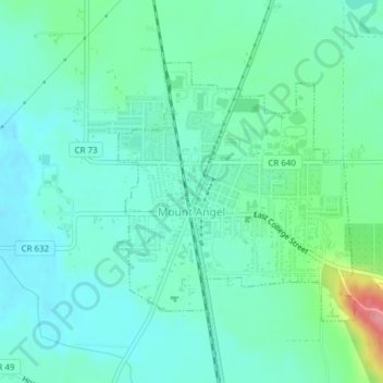
Nombre: Mapa topográfico Mount Angel, altitud, relieve.
Lugar: Mount Angel, Marion County, Oregon, United States (45.06008 -122.80715 45.07834 -122.78338)
Altitud media: 58 m
Altitud mínima: 36 m
Altitud máxima: 134 m
Rev. Fr. Adelhelm Odermatt, O.S.B., came to Oregon in 1881 with a contingent of Benedictine monks from Engelberg, Switzerland, in order to establish a new American daughter house. After visiting several locations, he found Lone Butte to be the ideal location for a new abbey, and shortly afterwards ministered to several local Roman Catholic parishes, about the same time large numbers of immigrants from Bavaria settled in the area. Due to his efforts, the city, post office and the nearby elevation Lone Butte came to be known as Mount Angel (an English translation of Engelberg) in 1883. He also established Mount Angel Abbey, a Benedictine monastery and school, which was moved permanently to Mt. Angel in 1884.