
Mapa topográfico Trebein
Mapa interactivo
Haga clic en el mapa para ver la altitud.
Acerca de este mapa
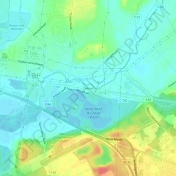
Nombre: Mapa topográfico Trebein, altitud, relieve.
Altitud media: 257 m
Altitud mínima: 238 m
Altitud máxima: 303 m
Otros mapas topográficos
Haga clic en un mapa para ver su topografía, su altitud y su relieve.
Beavercreek
United States > Ohio > Greene County
Beavercreek, Greene County, Ohio, United States
Altitud media: 274 m
Cedarville
United States > Ohio > Greene County
Cedarville, Cedarville Township, Greene County, Ohio, United States
Altitud media: 318 m
Bowersville
United States > Ohio > Greene County
Bowersville, Jefferson Township, Greene County, Ohio, United States
Altitud media: 329 m
Spring Valley
United States > Ohio > Greene County
Spring Valley, Spring Valley Township, Greene County, Ohio, United States
Altitud media: 252 m
Twin Towers County Park
United States > Ohio > Greene County
Twin Towers County Park, Bath Township, Greene County, Ohio, United States
Altitud media: 307 m
Clifton
United States > Ohio > Greene County
Clifton, Miami Township, Greene County, Ohio, 45316, United States
Altitud media: 312 m
Byron
United States > Ohio > Greene County
Byron, Bath Township, Greene County, Ohio, 45324, United States
Altitud media: 280 m
Dayton Aviation Heritage National Historical Park
United States > Ohio > Greene County > Oakwood
Dayton Aviation Heritage National Historical Park, Oakwood, Bath Township, Greene County, Ohio, United States
Altitud media: 268 m
Gunnerville
United States > Ohio > Greene County
Gunnerville, Jefferson Township, Greene County, Ohio, 45164, United States
Altitud media: 319 m
Fairborn
United States > Ohio > Greene County
Fairborn, Greene County, Ohio, United States
Altitud media: 272 m
Sugarcreek MetroPark
United States > Ohio > Greene County > Bellbrook
Sugarcreek MetroPark, Bellbrook, Sugarcreek Township, Greene County, Ohio, United States
Altitud media: 269 m
Ross Township
United States > Ohio > Greene County
Ross Township, Greene County, Ohio, United States
Altitud media: 330 m
Sugarcreek Township
United States > Ohio > Greene County
Sugarcreek Township, Greene County, Ohio, United States
Altitud media: 273 m
Xenia
United States > Ohio > Greene County
Xenia, Greene County, Ohio, 45385, United States
Altitud media: 288 m
Woodland Hills
United States > Ohio > Greene County
Woodland Hills, Bath Township, Greene County, Ohio, 45435, United States
Altitud media: 265 m
The Narrows State Scenic River Reserve
United States > Ohio > Greene County
The Narrows State Scenic River Reserve, Beavercreek Township, Greene County, Ohio, 45301, United States
Altitud media: 265 m
Bellbrook
United States > Ohio > Greene County
Bellbrook, Greene County, Ohio, 45305, United States
Altitud media: 262 m
Jamestown
United States > Ohio > Greene County
Jamestown, Silvercreek Township, Greene County, Ohio, United States
Altitud media: 324 m
Yellow Springs
United States > Ohio > Greene County
Yellow Springs, Miami Township, Greene County, Ohio, 45387, United States
Altitud media: 305 m
Wilberforce
United States > Ohio > Greene County > Wilberforce
Wilberforce, Xenia Township, Greene County, Ohio, 45384, United States
Altitud media: 297 m