
Mapa topográfico Amarkantak
Mapa interactivo
Haga clic en el mapa para ver la altitud.
Acerca de este mapa
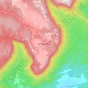
Nombre: Mapa topográfico Amarkantak, altitud, relieve.
Altitud media: 884 m
Altitud mínima: 580 m
Altitud máxima: 1,131 m
Amarkantak is located in the state of Madhya Pradesh in India at 22°40′N 81°45′E / 22.67°N 81.75°E / 22.67; 81.75. It has an average elevation of 1,048 metres (3,438 ft). Roads running through Rewa, Shahdol, Anuppur, Jabalpur, Katni and Pendra connect it. The nearest railway stations are Anuppur and Pendra Road 43 km via Keonchi and only 28 km via Jwaleshwar. The nearest airport is Dumna Jabalpur (Jabalpur Airport) in the city of Jabalpur, Madhya Pradesh (240 km) which has daily flight service to Delhi and Mumbai.