
Mapa topográfico Village of Mamaroneck
Mapa interactivo
Haga clic en el mapa para ver la altitud.
Village of Mamaroneck
Other areas of the town include Heathcote Hill, overlooking the harbor, Harbor Heights (the heights) to the northeast, Old Rye Neck (settled in the 1880s), Rye Neck (settled in the 1920s and 1930s), Orienta, and Washingtonville, better known as "The Flats", due to the flat, low-lying topography of the area.
Acerca de este mapa
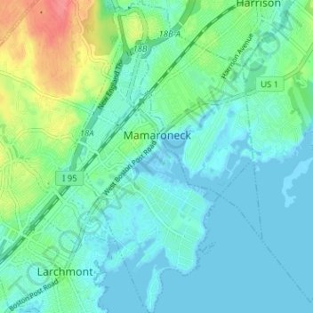
Nombre: Mapa topográfico Village of Mamaroneck, altitud, relieve.
Altitud media: 15 m
Altitud mínima: -3 m
Altitud máxima: 65 m
Otros mapas topográficos
Haga clic en un mapa para ver su topografía, su altitud y su relieve.
Ward Pound Ridge Reservation
United States > New York > Westchester County > Town of Pound Ridge
Altitud media: 164 m
Riveredge Trailer Park
United States > New York > Westchester County > Town of Cortlandt > Verplanck
Altitud media: 14 m
Isle of San Souci
United States > New York > Westchester County > City of New Rochelle
Altitud media: 7 m
Lake Waccabuc
United States > New York > Westchester County > Town of Lewisboro > Waccabuc
Altitud media: 173 m
Sherman Park
United States > New York > Westchester County > Town of Mount Pleasant > Thornwood
Altitud media: 133 m
West Harrison Village Green
United States > New York > Westchester County > Town/Village of Harrison > East White Plains
Altitud media: 79 m
Jefferson Valley
United States > New York > Westchester County > Jefferson Valley-Yorktown
Altitud media: 178 m
Fenmore Park
United States > New York > Westchester County > Town/Village of Harrison
Altitud media: 38 m
Bronxville Heights
United States > New York > Westchester County > City of Yonkers
Altitud media: 63 m
Mount Hope
United States > New York > Westchester County > Village of Hastings-on-Hudson
Altitud media: 60 m
New York, Westchester and Boston Railway
United States > New York > Westchester County > Village of Pelham > North Pelham
Altitud media: 28 m
Sleepy Hollow Manor
United States > New York > Westchester County > Village of Sleepy Hollow > Sleepy Hollow Manor
Altitud media: 41 m
Spring Valley
United States > New York > Westchester County > Town of Ossining > Ossining > Spring Valley
Altitud media: 115 m
Sarles Corners
United States > New York > Westchester County > Town of Pound Ridge
Altitud media: 141 m
Secor Gardens
United States > New York > Westchester County > Village of Scarsdale
Altitud media: 70 m