
Mapa topográfico Thousand Oaks
Mapa interactivo
Haga clic en el mapa para ver la altitud.
Acerca de este mapa
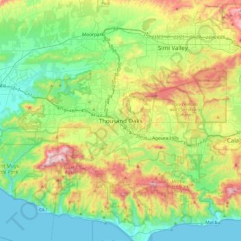
Nombre: Mapa topográfico Thousand Oaks, altitud, relieve.
Altitud media: 288 m
Altitud mínima: 0 m
Altitud máxima: 918 m
Otros mapas topográficos
Haga clic en un mapa para ver su topografía, su altitud y su relieve.
Thousand Oaks
United States > California > Ventura County > Thousand Oaks
Thousand Oaks, Ventura County, California, United States
Altitud media: 303 m
Newbury Park
United States > California > Ventura County > Thousand Oaks
Newbury Park, Thousand Oaks, Ventura County, CAL Fire Southern Region, California, 91320, United States
Altitud media: 262 m
Greenwich Village
United States > California > Ventura County > Thousand Oaks
Greenwich Village, Thousand Oaks, Ventura County, CAL Fire Southern Region, California, 91360, United States
Altitud media: 275 m
Westlake Village
United States > California > Ventura County > Thousand Oaks
Westlake Village, Thousand Oaks, Ventura County, CAL Fire Southern Region, California, 91361, United States
Altitud media: 305 m
Ventu Park
United States > California > Ventura County > Thousand Oaks > Newbury Park
Ventu Park, Newbury Park, Thousand Oaks, Ventura County, CAL Fire Southern Region, California, 91320, United States
Altitud media: 250 m