
Mapa topográfico Herxheim
Mapa interactivo
Haga clic en el mapa para ver la altitud.
Acerca de este mapa
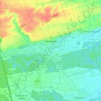
Nombre: Mapa topográfico Herxheim, altitud, relieve.
Altitud media: 130 m
Altitud mínima: 112 m
Altitud máxima: 162 m
Otros mapas topográficos
Haga clic en un mapa para ver su topografía, su altitud y su relieve.
Brunnel
Germany > Rhineland-Palatinate > Landkreis Südliche Weinstraße > Steinfeld
Brunnel, Steinfeld, Bad Bergzabern, Landkreis Südliche Weinstraße, Rhineland-Palatinate, Germany
Altitud media: 140 m
Vorderweidenthal
Germany > Rhineland-Palatinate > Landkreis Südliche Weinstraße > Vorderweidenthal
Vorderweidenthal, Bad Bergzabern, Landkreis Südliche Weinstraße, Rhineland-Palatinate, Germany
Altitud media: 298 m
Altdorf
Germany > Rhineland-Palatinate > Landkreis Südliche Weinstraße > Altdorf
Altdorf, Edenkoben, Landkreis Südliche Weinstraße, Rhineland-Palatinate, 67482, Germany
Altitud media: 148 m
Dierbach
Germany > Rhineland-Palatinate > Landkreis Südliche Weinstraße > Dierbach
Dierbach, Bad Bergzabern, Landkreis Südliche Weinstraße, Rhineland-Palatinate, Germany
Altitud media: 162 m