
Mapa topográfico Darts Mills
Mapa interactivo
Haga clic en el mapa para ver la altitud.
Acerca de este mapa
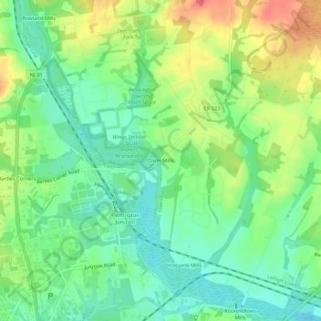
Nombre: Mapa topográfico Darts Mills, altitud, relieve.
Altitud media: 49 m
Altitud mínima: 24 m
Altitud máxima: 86 m
Otros mapas topográficos
Haga clic en un mapa para ver su topografía, su altitud y su relieve.
Three Bridges
United States > New Jersey > Hunterdon County > Readington Township
Three Bridges, Readington Township, Hunterdon County, New Jersey, 08887, United States
Altitud media: 48 m
Pleasant Run
United States > New Jersey > Hunterdon County > Readington Township
Pleasant Run, Readington Township, Hunterdon County, New Jersey, 08887, United States
Altitud media: 63 m
Centerville
United States > New Jersey > Hunterdon County > Readington Township
Centerville, Readington Township, Hunterdon County, New Jersey, 08853, United States
Altitud media: 49 m
Dreahook
United States > New Jersey > Hunterdon County > Readington Township
Dreahook, Readington Township, Hunterdon County, New Jersey, 08889, United States
Altitud media: 80 m
Potterstown
United States > New Jersey > Hunterdon County > Readington Township
Potterstown, Readington Township, Hunterdon County, New Jersey, 08833, United States
Altitud media: 83 m
Stanton
United States > New Jersey > Hunterdon County > Readington Township
Stanton, Readington Township, Hunterdon County, New Jersey, 08885, United States
Altitud media: 97 m
Riverside
United States > New Jersey > Hunterdon County > Readington Township
Riverside, Readington Township, Hunterdon County, New Jersey, 08887, United States
Altitud media: 46 m
Whitehouse Station
United States > New Jersey > Hunterdon County > Readington Township
Whitehouse Station, Readington Township, Hunterdon County, New Jersey, 08889, United States
Altitud media: 61 m