
Haz una donación
Mapa topográfico Sikar
Haga clic en el mapa para ver la altitud.
Haz una donación
Acerca de este mapa
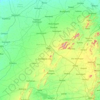
Nombre: Mapa topográfico Sikar, altitud, relieve.
Lugar: Sikar, Sikar District, Rajasthan, 332001, India (26.88333 74.46667 28.28333 75.86667)
Altitud media: 394 m
Altitud mínima: 275 m
Altitud máxima: 1,027 m
Haz una donación
Otros mapas topográficos
Haga clic en un mapa para ver su topografía, su altitud y su relieve.
Jalore
The district is bounded on the northwest by Barmer District, on the northeast by Pali District, on the southeast by Sirohi District, and by Banaskantha District of Gujarat state on the southwest. The total area of the district is 10,640 km2 (4,108 sq mi). The altitude is 268 m, latitude is 25.22 N and…
Altitud media: 183 m
Haz una donación
Haz una donación
Haz una donación
Hindaun
India > Rajasthan > Hindaun Tehsil
Hindaun has an average elevation of 235 metres (771 ft). Its distance from the state capital of Jaipur is around 150 km.
Altitud media: 230 m
Pokaran
India > Rajasthan > Pokaran Tehsil
Pokhran is located 112 km east of Jaisalmer city, 172 km northwest of Jodhpur and 225 km south of Bikaner by road. It lies on Jaisalmer to Jodhpur railway line. It is situated at 27°05′42″N 71°45′11″E / 27.095°N 71.753°E / 27.095; 71.753 and has an average elevation of 233 metres (764 feet).
Altitud media: 229 m
Haz una donación
Haz una donación
Sirohi
India > Rajasthan > Sirohi Tehsil
Sirohi is located at 24°53′06″N 72°51′45″E / 24.885°N 72.8625°E / 24.885; 72.8625. It has an average elevation of 321 metres (1053 ft).
Altitud media: 321 m
Dausa
The general topographic elevation in the district is between 250 m to 300 m above sea level. Elevation ranges from a minimum of 203.2 m above sea level in Mahwa in the northeastern part of the district and maximum of 596.3 m above sea level in Bandikui in northern part of the district.
Altitud media: 313 m
Haz una donación
Karauli
The Chambal River forms the south-eastern boundary of the district, 5 km from Mandrayal across which lies the state of Madhya Pradesh. While almost the entire district is covered by hills and ravines, there are no lofty peaks, the highest having an elevation of less than 1400 feet above sea level.
Altitud media: 263 m
Haz una donación
Haz una donación
karauli
India > Rajasthan > Karauli Tehsil
Karauli is located at 26°30′N 77°01′E / 26.5°N 77.02°E / 26.5; 77.02. It has an average elevation of 275 metres (902 ft).
Altitud media: 273 m
Haz una donación
Haz una donación
Haz una donación
Haz una donación