
Haz una donación
Mapa topográfico Tipaturu
Haga clic en el mapa para ver la altitud.
Haz una donación
Tipaturu
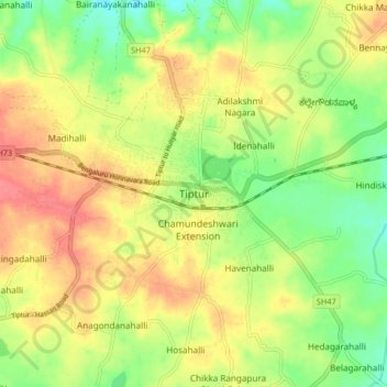
Tiptur has been surrounded by from the west side Arsikere and channarayapatna. from the east side Chikkanayakana halli, Gubbi, Turuvekere. Tiptur is approximately 73 km (45 mi) west of Tumkur along National Highway 206 (now renumbered as National Highway 48). It is at a distance of 140 km (87 mi) northwest from the state capital, Bangalore. It lies on the Bangalore-Miraj railway line. Tiptur has an average elevation of 861 metres (2,825 ft). The average temperature in summer is 34 °C (93 °F) and in winter is 20 °C (68 °F).
Haz una donación
Acerca de este mapa
Nombre: Mapa topográfico Tipaturu, altitud, relieve.
Lugar: Tipaturu, Tipaturu taluk, Tumakuru, Karnataka, 572200, India (13.21858 76.43377 13.29858 76.51377)
Altitud media: 855 m
Altitud mínima: 823 m
Altitud máxima: 886 m
Haz una donación