
Haz una donación
Mapa topográfico Kanhangad
Haga clic en el mapa para ver la altitud.
Haz una donación
Kanhangad
Kanhangad lies at 12°18′0″N 75°5.4′0″E in the geographic map of Kasaragod. It is a coastal town which has a varied topography with plain areas in the centre of the city. The landscape is dominated by the characteristic coconut palms accompanying rolling hills and streams flowing into the sea. In the East, there are hilly areas of Madikai . The western region has powdered sand and a mix of laterite and alluvial soil in the areas between. The hilly areas typically consists of red sand.
Haz una donación
Acerca de este mapa
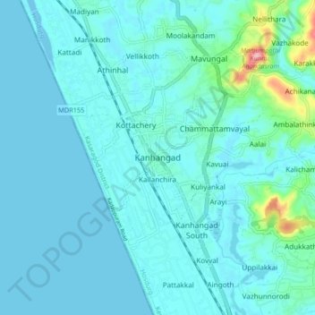
Nombre: Mapa topográfico Kanhangad, altitud, relieve.
Lugar: Kanhangad, Hosdurg, Kasaragod District, Kerala, 671315, India (12.27356 75.05246 12.35356 75.13246)
Altitud media: 18 m
Altitud mínima: -6 m
Altitud máxima: 169 m
Haz una donación
Otros mapas topográficos
Haga clic en un mapa para ver su topografía, su altitud y su relieve.