
Mapa topográfico Bell Hill
Mapa interactivo
Haga clic en el mapa para ver la altitud.
Bell Hill
Bell Hill is located in eastern Clallam County and is bordered to the north by the city of Sequim. The community is named for the hill that it sits on, which rises to an elevation of over 1,000 feet (300 m) above sea level, or more than 800 feet (240 m) above the center of Sequim. Bell Hill actually has two peaks, or hillocks. The Eastern hillock is approximately 950 feet (290 m) above sea level. The Western hillock is relatively exposed, while the eastern hillock is forested with Douglas fir and Pacific madrone (madrone).
Acerca de este mapa
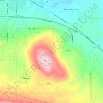
Nombre: Mapa topográfico Bell Hill, altitud, relieve.
Lugar: Bell Hill, Clallam County, Washington, United States (48.04317 -123.11862 48.07602 -123.05857)
Altitud media: 139 m
Altitud mínima: 21 m
Altitud máxima: 314 m